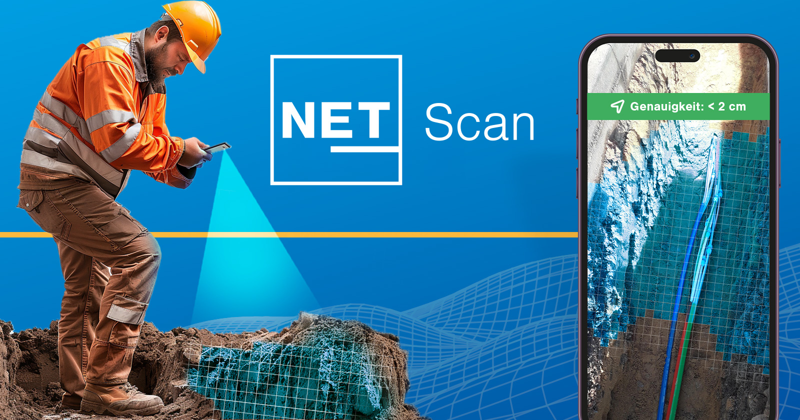
Precision meets efficiency – high-precision 3D capture of open trenches
NET Scan is the innovative 3D scanning application for field service: construction progress, routes, and infrastructure are digitally captured in seconds via smartphone – with LiDAR, high-precision GNSS, and an open interface for further use in any target system.
NET Scan improves the quality of network expansion by providing a precise and accurate representation of on-site conditions in 2D and 3D.
By combining LiDAR and high-precision GNSS in a single, easy-to-use mobile device, NET Scan enables construction crews to capture a scan and share it with the rest of the project team for real-time collaboration.
NET Scan is the preferred tool for capturing photos, measurements, and accurate digital twins.
Precise network analysis – added value for your team

Network operator

Construction supervisor

Construction crews
FOR OPERATORS
- High-quality construction documentation
With high-precision digital twins in 3D, high-resolution georeferenced photos, and measurement of point and line objects in augmented reality. - Better advance information for more accurate planning
NET Scan provides planners with an additional source of data on the condition of the site prior to construction. Capture the actual conditions on site, take measurements to ensure compliance with approvals, and identify potential construction issues before they arise. - Regulatory compliance
In many areas, precise documentation in GIS inventory plans is required for all underground infrastructure. With RTK-corrected GNSS, scans, pipe runs, and manhole positions can be verifiably captured with an accuracy of 10 cm or better by simply walking around the construction site.
-
Operational efficiency
The exact location of infrastructure can be verified at any time. Verifiable as-built plans in 2D and 3D mean that there is no ambiguity about what is in the ground. You can also check the configurations of cabinets or manholes, cable routing, or splice configurations without visiting the site.
FOR CONSTRUCTION SUPERVISORS
- 3D insights for better planning
Pre-site survey with NET Scan for accurate, measurable digital twins of your development area. Identify obstacles and discover challenges before construction crews are dispatched.
- Comprehensive documentation
Every manhole, handhole, sewer, and borehole can be easily documented, with before and after conditions. NET Scan enables field teams to document work performed and eliminate progress calls.
- Real-time collaboration to resolve challenges in the field
Send photos and a scan in real time to the planner to illustrate necessary changes and communicate with clear and accurate documentation.
- Monitoring subcontractors and construction progress
Construction progress is displayed in near real time with a bird's-eye view that shows where work has been completed. Review and inspect completed construction jobs from anywhere with high-resolution georeferenced photos and measurable 3D digital twins.
FOR CONSTRUCTION CREWS
- Intuitive progress documentation with NET Scan
NET Scan impresses with its ease of use. As an integrated solution comprising hardware, software, and cloud technology, the system enables seamless recording of construction progress: with a single click, users start recording, walk around the construction site, and then send the data. Progress is automatically documented and uploaded to the cloud, allowing work statuses to be checked efficiently and potential problems to be identified at an early stage.
- Compare conditions before and after the construction project
Perform a scan before and after the work is completed to document the success of the renovation in a comprehensible manner. This allows you to create consistent evidence, avoid discrepancies about the initial condition and damage incurred, and reduce potential discussions in the long term.
- Transparent communication in the field
A one-minute tour of the construction site is all it takes to record all relevant changes for the inventory documentation – including precise map positions. This keeps field teams efficient and avoids ambiguities about route alignments or structural adjustments.
Step by step to the digital twin

01
Importing a plan

02
Scan and photograph the construction site

03
Review and validate
04
Export results
Overview of the most important features in NET Scan

Mobile app
- Preconfigured hardware with LiDAR and GNSS
- NET Scan app for easy data capture in augmented reality
- Geolocated photos
- Capture point and line objects with attributes
- Track progress in the map view

Cloud-based collaboration
- Highly detailed background map of all scans
- New scans are visible in near real time
- Integrated ticket system

QS and documentation
- High-resolution geolocated photos
- Audit measurements from any browser
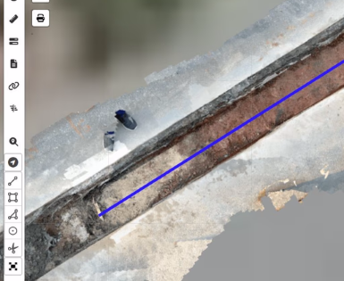
- Inspection of scans in 3D
- Export of measurements in common formats (Shape, KML, DXF)
The NET Scan Kit

Everything a team needs to capture pre-construction surveys, construction progress, and documentation, including:
LiDAR scanner for precise measurements
High-precision GNSS receiver
Rugged protective case for the construction site
Battery life for an entire workday

Software that works
NET Scan app for easy mobile capture
NET Cloud as a web portal for collaboration and QA
NET Cloud 3D Viewer for accurate measurements and validation
Service to stay connected
Mobile data for uploading scans and photos
RTK service for up to 1 cm GNSS accuracy
Unlimited cloud storage
Get started with NET Scan within 2 weeks

Project setup 1-2 days
Create a project, upload a design, and you're ready to go. Advanced configuration can include markup types and materials.

Onboarding of construction crews 1 week
NET Scan is easy to use, and construction crews can get started in no time. With a quick start guide, video support, and live support for corporate customers.

System integration 3-5 days
Export the survey data to AutoCAD or any GIS system and insert the Scan Orthophoto base maps as WMS layers. Drag data collected via NET Scan directly into NET Engineering.
FAQ - Quick answers to frequently asked questions
What level of precision can be achieved?
- All scans can be used for measurements with an accuracy of up to 1 inch.
- The actual position accuracy achieved depends on several factors, such as satellite visibility and the availability and quality of the GNSS correction service during recording. Under optimal conditions, a position accuracy of 10 cm or better is possible.
What is included in a scan kit?
- LiDAR-enabled iPhone Pro
- High-precision GNSS receiver
- Compatible mount
- Protective case
NET Scan can be integrated with

AutoCAD
DXF exports and WMS layers with scan orthophotos

ESRI
Shapefiles

Basemap-Webdienst
WMS and WMTS
TKI NET Suite
Direct integration and design uploads to NET Cloud

QGIS
Shapefiles and WMS layers with scan orthophotos

Google Earth
KML As-builts
Contact our sales team
Contact us for a personal consultation, prices, or further information about our TKI NET Suite.
You are also welcome to contact us by phone:
Sales Team Europe
+49 371 52 333 500
Sales Team USA
+1 646-405-1017